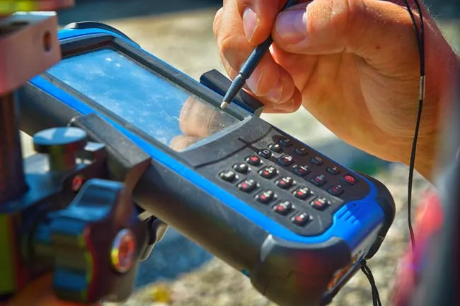
The “Enhancing Maritime Operations: Handheld GIS Tracker Deployment for Bangladesh Coast Guard” project represents a significant advancement in maritime technology aimed at bolstering the capabilities of the Bangladesh Coast Guard in safeguarding the nation’s maritime interests. This initiative encompasses the complete process of supplying, installing, and commissioning state-of-the-art handheld Geographic Information System (GIS) trackers for use by the Coast Guard personnel. Supply and Installation: The project involves the procurement of cutting-edge handheld GIS trackers, specialized devices equipped with advanced GPS technology, mapping capabilities, and real-time data transmission functionalities. These trackers are designed to provide accurate and up-to-date geospatial information, enabling Coast Guard personnel to visualize and analyze maritime activities, vessel movements, and critical points of interest within the maritime domain. The installation phase focuses on integrating the handheld GIS trackers seamlessly into the operational infrastructure of the Bangladesh Coast Guard. Each tracker is equipped with a user-friendly interface and ergonomic design, ensuring ease of use for field operatives. Rigorous testing and calibration procedures are conducted during this phase to ensure optimal functionality and reliability. Commissioning and Training: Once installed, the project includes a comprehensive commissioning process. Coast Guard personnel undergo specialized training to effectively utilize the capabilities of the handheld GIS trackers. Training sessions cover topics such as device operation, data interpretation, mapping techniques, and real-time communication protocols. The aim is to equip Coast Guard officers with the necessary skills to maximize the potential of the GIS trackers in their daily operational activities. Operational Benefits: The deployment of handheld GIS trackers offers a range of operational benefits to the Bangladesh Coast Guard: Enhanced Situational Awareness: Coast Guard personnel gain access to real-time geospatial data, allowing them to monitor vessel traffic, identify potential threats, and respond swiftly to maritime incidents or emergencies. Effective Resource Allocation: The GIS trackers provide insights into maritime patterns and trends, enabling the Coast Guard to allocate resources more efficiently and respond proactively to emerging situations. Improved Coordination: GIS-enabled tracking facilitates better coordination among Coast Guard units, enabling them to work together seamlessly in maritime surveillance, search and rescue operations, and law enforcement activities. Data-Driven Decision Making: Accurate geospatial information empowers decision-makers to make informed choices, allocate assets strategically, and devise effective strategies for maritime security and response. National Security and Maritime Safety: The deployment of handheld GIS trackers significantly contributes to strengthening national security and ensuring maritime safety for Bangladesh. By equipping the Coast Guard with cutting-edge technology, the project enhances the nation’s ability to monitor and manage its maritime domain, safeguarding against threats such as illegal fishing, smuggling, piracy, and other illicit activities. In summary, the “Enhancing Maritime Operations: Handheld GIS Tracker Deployment for Bangladesh Coast Guard” project stands as a testament to Bangladesh’s commitment to leveraging advanced technology to enhance maritime security, safety, and operational efficiency. Through the integration of GIS trackers, the Coast Guard is poised to achieve greater situational awareness, improved coordination, and effective decision-making, thereby safeguarding the nation’s maritime interests and ensuring a secure maritime environment. |